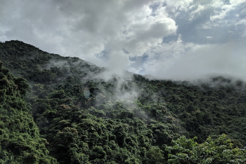
Tropical rainforests have an outsized role in the world, with their significance marked by the World Rainforest Day. Of the Earth’s ecosystems, rainforests support the largest variety of plants and animal species, house the majority of indigenous groups still living in isolation from the rest of humanity, and power the mightiest rivers. Rainforests lock up vast amounts of carbon, moderate local temperature, and influence rainfall and weather patterns at regional and planetary scales.
–
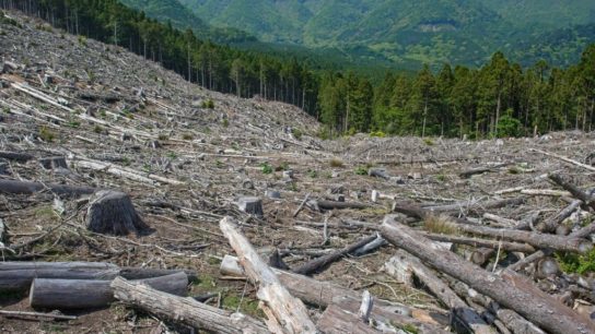
Despite their importance however, deforestation in the world’s tropical forests has remained persistently high since the 1980s due to rising human demand for food, fibre, and fuel and the failure to recognize the value of forests as healthy and productive ecosystems. Since 2002, an average of 3.2 million hectares of primary tropical forests—the most biodiverse and carbon-dense type of forest—have been destroyed per year. An even larger area of secondary forest is cleared or degraded.
Below is a brief look at the state of the world’s largest remaining tropical rainforests.
Note: All figures below are based on 2020 data from the University of Maryland (UMD) and World Resources Institute (WRI) using a 30% canopy cover threshold. Tree cover loss does not account for regrowth, reforestation, or afforestation.
The World’s Top 10 Biggest Rainforests
1. The Amazon Rainforest
The Amazon is the world’s largest and best known tropical rainforest. As measured by primary forest extent, the Amazon rainforest is more than three times larger than that of the Congo Basin, the world’s second largest rainforest. The Amazon rainforest accounts for just over a third of tree cover across the tropics.
The Amazon River, which drains an area nearly the size of the forty-eight contiguous United States, is the world’s biggest river. It carries more than five times the volume of the Congo or twelve times that of the Mississippi. By one estimate, 70% of South America’s GDP is produced in areas that receive rainfall generated by the Amazon rainforest. This includes South America’s agricultural breadbasket and some of its largest cities.
Due to its size, the Amazon leads all tropical forest areas in terms of its annual area of forest loss. Between 2002 and 2019, more than 30 million hectares of primary forest was cleared in the region, or about half the world’s total tropical primary forest loss during that period.
The Amazon is thought to house more than half the world’s “uncontacted” tribes living in voluntary isolation from the rest of humanity. However the vast majority of indigenous peoples in the Amazon live in cities, towns, and villages.
You might also like: Insects Decline on Land, Fare Better in Water, Study Finds
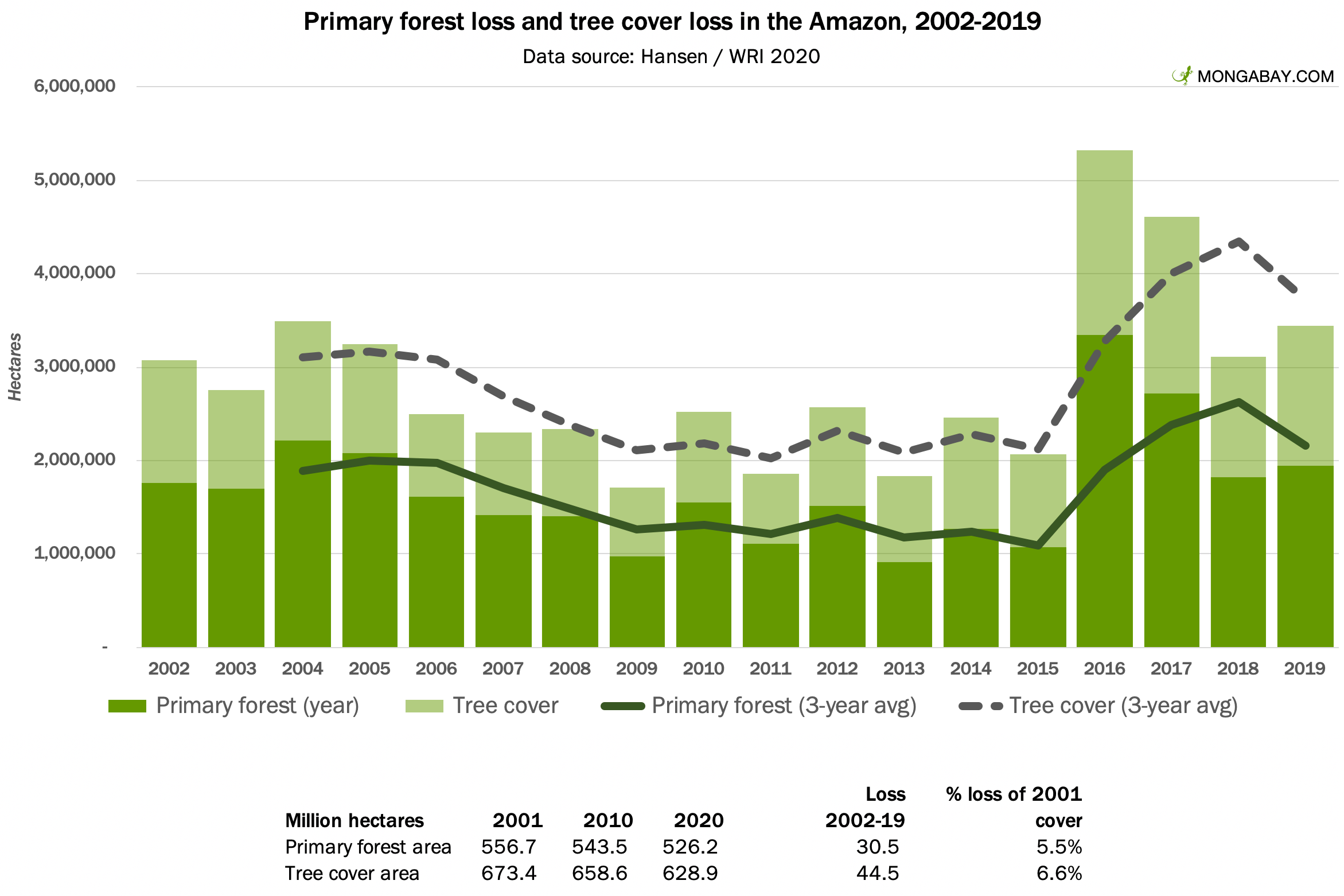
Extent: 628 million hectares of tree cover, including 526 million hectares of primary forest, in 2020.
Major countries: About 60 percent of the Amazon rainforest lies within the borders of Brazil; the balance is found in parts of Peru (13%), Colombia (8%), Venezuela (6%), Bolivia (6%), Guyana (3%), Ecuador (2%), and Suriname (2%), as well as French Guiana (1%), a department of France.
Most famous species: Jaguar; tapir; capybara; river dolphins; various monkeys and parrots. Bulk numbers: more than 40,000 plant species, including 16,000 tree species; 3,000 fish; 1,300 birds, 1,000 amphibians; 430 mammals, and 400 reptiles.
Deforestation trend: Rising in most countries, led by Brazil. The Amazon lost over 30 million hectares of primary forest (5.5% of the 2001 extent) and 44.5 million hectares of tree cover (6.6%) between 2002 and 2019.
2. The Congo Rainforest
The second largest block of tropical rainforest is found in the Congo Basin, which drains an area of 3.7 million square kilometers. The majority of the Congo rainforest lies within the Democratic Republic of the Congo (DRC), which accounts for 60 percent of Central Africa’s lowland primary forest. Gabon, Republic of the Congo, Cameroon, Central African Republic, and Equatorial Guinea account for nearly all the rest of the Congo Basin rainforest.
Until the early 2010s, deforestation in the Congo Basin was relatively low. War and chronic political instability, poor infrastructure, and lack of large-scale industrial agriculture help limit forest loss in the region. Most deforestation was driven by subsistence activities, though degradation due to logging was substantial. The situation is changing however: deforestation has been trending sharply upward in recent years.
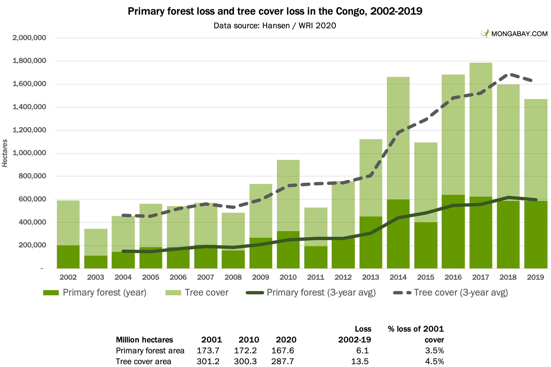
Extent: 288 million hectares of tree cover, including 168 million hectares of primary forest, in 2020.
Major countries: The Democratic Republic of the Congo (DRC) (60% of the Congo’s primary forest), Gabon (13%), Republic of the Congo (12%), Cameroon (10%), Central African Republic (3%), and Equatorial Guinea (1%).
Most famous species: Forest elephants; okapi; great apes including gorillas, bonobos, and chimps.
Deforestation trend: Deforestation is rising rapidly though it remains lower on a percentage basis than other major forest regions. The Congo lost over 6 million hectares of primary forest (3.5% of the 2001 extent) and 13.5 million hectares of tree cover (4.5%) between 2002 and 2019.
3. Australiasian Realm
The Australiasian rainforest includes tropical forests on the island of New Guinea and northeastern Australia as well as scattered islands that were connected when sea levels dropped during that last ice age. As a consequence of this linkage, both land masses have common assemblages of plants and animals, while conspicuously lacking groups found on islands further west. For example, cats, monkeys, and civets are absent from New Guinea and Australia, but both have an unusually high diversity of marsupials like kangaroos, wallabies, cuscuses, and opossums.
Virtually all this region’s primary tropical rainforest is on the island of New Guinea, which is roughly split between Indonesia and Papua New Guinea.
New Guinea is the most linguistically diverse island on the planet with some 800 languages. There are believed to be a few uncontacted groups in remote parts of New Guinea.
Among major forest areas, Australiasia had the second lowest rate of primary forest loss since 2001, but deforestation is trending upward due to logging and conversion for plantations.
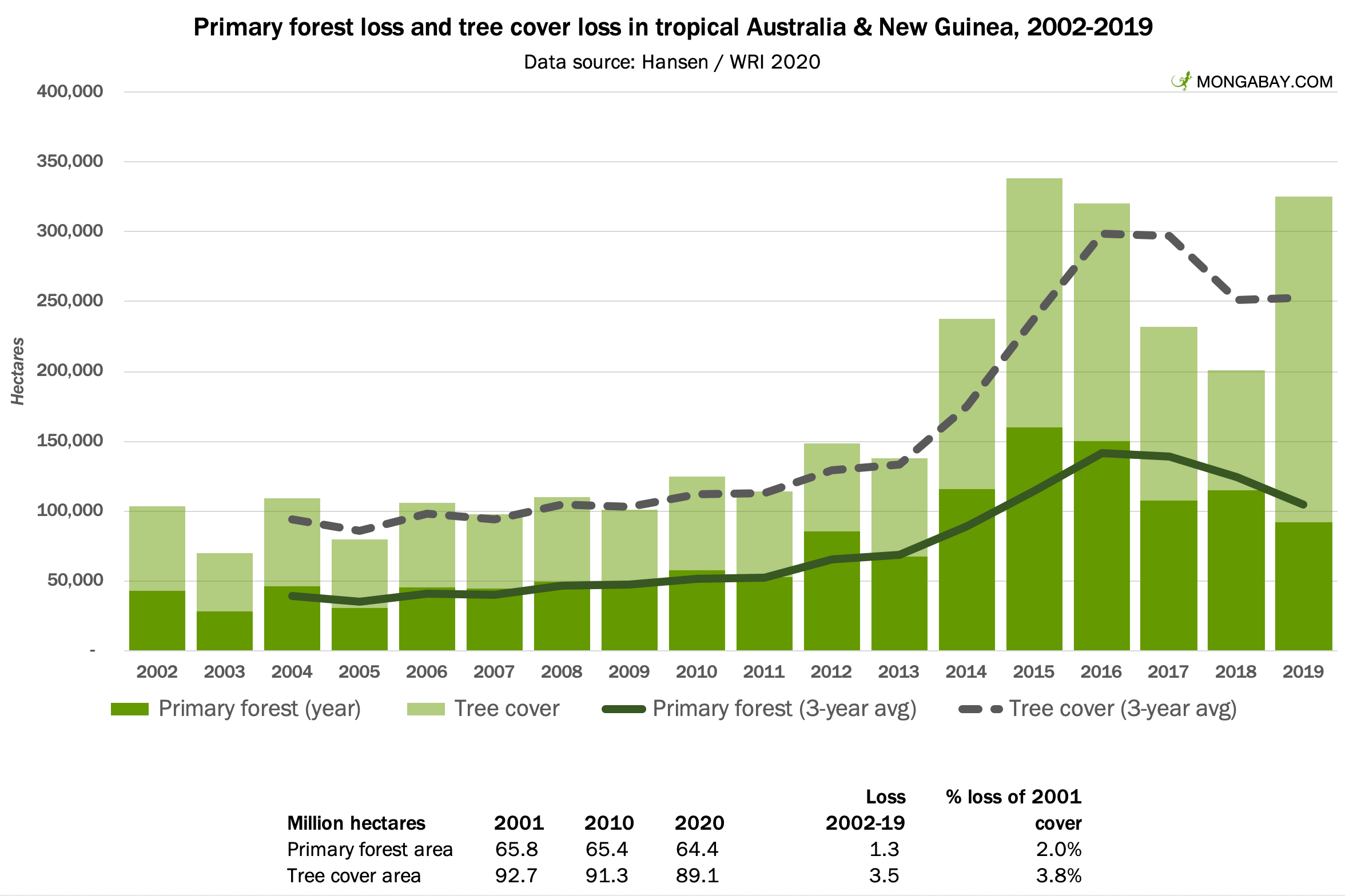
Extent: 89 million hectares of tree cover, including 64 million hectares of primary forest, in 2020.
Major countries: Indonesian provinces of Papua and West Papua (51% of the region’s primary forest), Papua New Guinea (49%), and Australia (under 1%).
Most famous species: Tree kangaroos; cassowaries; giant ground pigeons; saltwater crocodiles.
Deforestation trend: Deforestation is rising rapidly due to plantation agriculture, especially oil palm. The Indonesian part of New Guinea lost 605,000 hectares of primary forest since 2002 (1.8% of its 2001 cover), while PNG lost 732,000 hectares (2.2%). New Guinea is seen as the last frontier for large-scale agroindustrial expansion in Indonesia.
4. Sundaland
Sundaland includes the islands of Borneo, Sumatra, and Java, among others as well as Peninsular Malaysia. Most of the region’s remaining forest is on the island of Borneo, which is divided politically between Indonesia, Malaysia, and Brunei.
Sundaland lost the world’s largest share of primary forest cover between 2002 and 2019. Borneo lost 15% of such forests, while Sumatra lost 25%. Deforestation for oil palm and timber plantations, as well as fires set for land-clearing, are the biggest drivers of deforestation. However deforestation has been slowing since the mid-2010s.
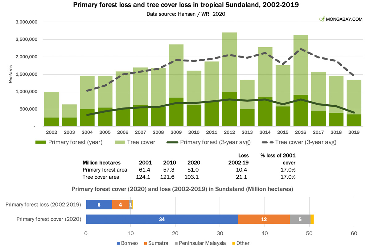
Extent: 103 million hectares of tree cover, including 51 million hectares of primary forest, in 2020.
Major countries: Indonesia (73% of the region’s primary forest cover) and Malaysia (26%). Brunei and Singapore have less than 1% of the region’s forests.
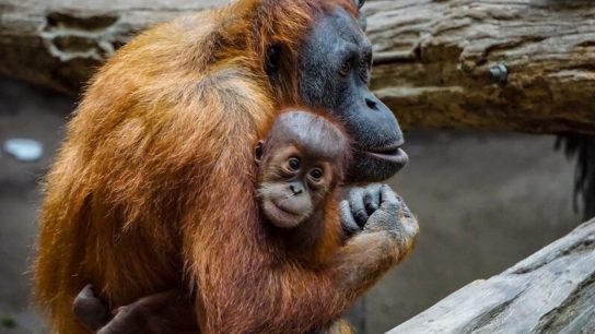
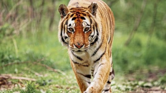
Most famous species: Elephants; orangutans; two species of rhino; tigers; various hornbill and monkey species.
Deforestation trend: Deforestation is the highest of any major forest region, but trending downward. Between 2002 and 2019, Borneo lost 5.8 million hectares of primary forest (15% of 2001 cover), Sumatra 3.8 million hectares (25%), and Peninsular Malaysia 726,000 hectares (14%). Indonesia accounted for 75% of primary forest loss in the region, compared with 25% for Malaysia.
5. Indo-Burma
The Indo-Burma region includes a mix of tropical forest types, from mangroves to lowland rainforests to seasonal forests. Historical large-scale forest loss due to human population pressure means that surviving forests in this region are more fragmented than other regions mentioned so far. Most of the region’s tree cover consists of plantations, crops, and secondary forests.
The largest extent of primary forests in this region are in Myanmar, which has about one-third of the total area.
Indo-Burma lost about 8% of its primary forests and 12% of its tree cover since 2001. Cambodia accounted for more than a third of the region’s primary forest loss during this period.
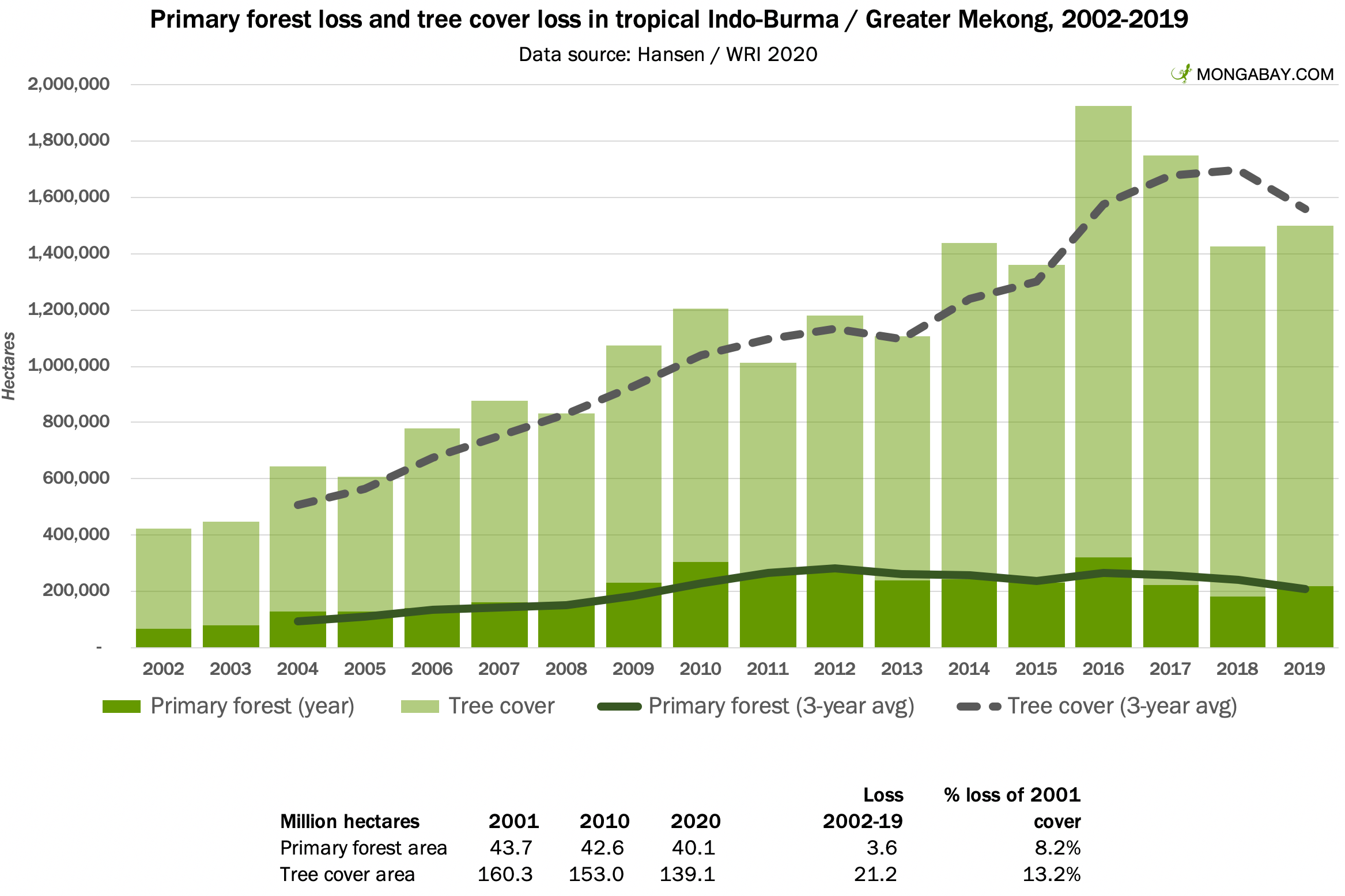
Extent: 139 million hectares of tree cover, including 40 million hectares of primary forest, in 2020.
Major countries: Myanmar (34% of the region’s primary forest cover), Laos (19%), Vietnam (15%), Thailand (14%), Cambodia (8%), far eastern India (6%), and parts of southern China (4%).
Most famous species: Elephants; two species of rhino; tigers; gibbons; leopards.
Deforestation trend: The rate of primary forest loss was roughly flat over the past 20 years, while tree cover loss is accelerating. Cambodia accounted for 34% of primary forest loss, followed by Laos (21%), Vietnam (18%), and Myanmar (16%). Cambodia lost over 28% of its 2001 primary forest cover over the period as natural forests were increasingly converted to plantations and industrial projects.
6. Mesoamerica
Mesoamerican rainforests extend from southern Mexico to southern Panama. Costa Rica’s rainforests are arguably the best known in the region thanks to its world-famous ecotourism industry, but the country ranks fifth in terms of primary forest cover.
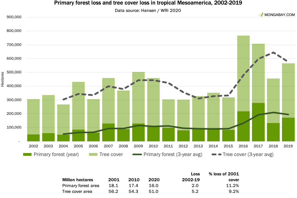
Extent: 51 million hectares of tree cover, including 16 million hectares of primary forest, in 2020.
Major countries: Mexico (39% of Mesoamerica’s primary forest cover), Guatemala (13%), Honduras (11%), Panama (11%), Nicaragua (10%), and Costa Rica (9%).
Most famous species: Jaguar; puma; tapir; peccary.
Deforestation trend: The rate of primary forest loss and tree cover loss accelerated toward the end of the 2010s driven by increasing incidence of fire, coupled with conversion of forests for cattle pasture, plantations, and smallholder agriculture. Mexico (534,000 hectares of primary forest loss), Guatemala (480,000), and Nicaragua (460,000) lost the greatest area of primary forest between 2002 and 2019. Costa Rica lost less than 2% of its primary forest during the period. In contrast, Nicaragua lost nearly 30%.
6. Wallacea
Wallacea represents a biogeographic oddity. When sea levels fell during the last ice age, islands to the west of this area joined continental Asia, while islands to the east got connected to land mass formed from Australia and New Guinea. As a result, Wallacea today has an unusual mix of species, drawing plant and animal groups from both regions, but also having high levels of endemism.
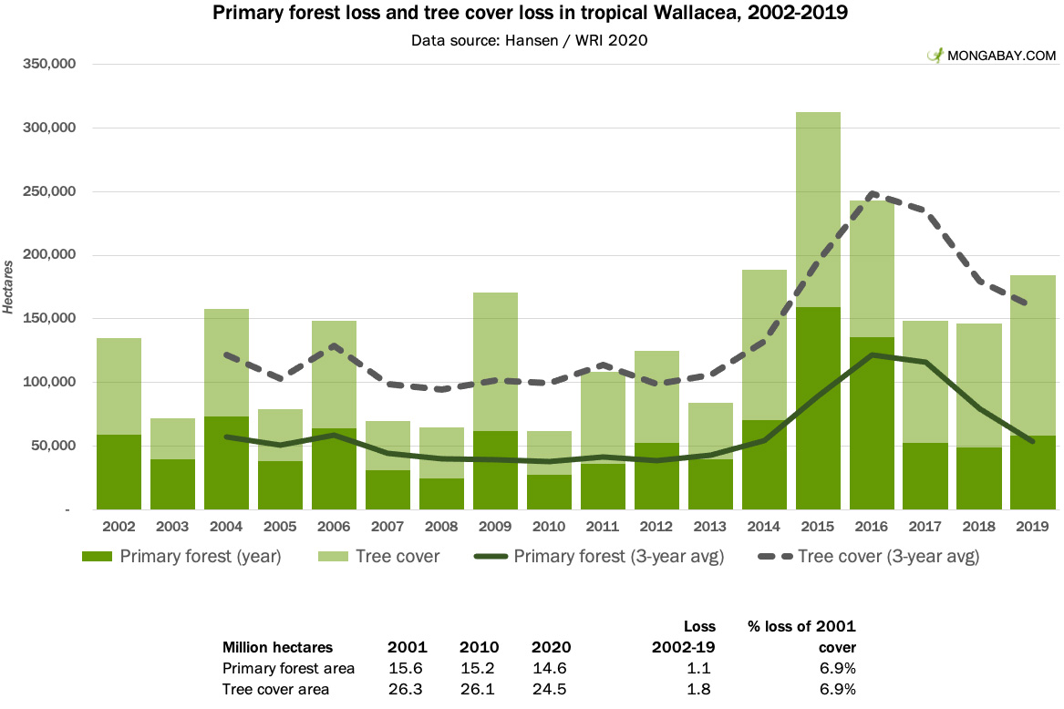
Extent: 24.4 million hectares of tree cover, including 14.6 million hectares of primary forest, in 2020.
Major countries: Indonesia. More than 60% of Wallacea’s primary forest cover is on the island of Sulawesi. The Maluku islands account for 34%.
Most famous species: Babirusa; tarsiers and various monkeys; hornbills; cuscuses.
Deforestation trend: The rate of primary forest loss and tree cover loss jumped in 2015 and 2016 following a particularly bad fire season. Deforestation for industrial plantations, including oil palm and coconut, increased in the 2010s.
7. Guinean Forests of West Africa
The Guinean Forests of West Africa consists of the lowland tropical forests that extend from Liberia and Sierra Leone to the Nigeria-Cameroon border. These forests have been greatly diminished by agriculture, including subsistence farming by small-holders and commercial cacao, timber, and oil palm plantations.
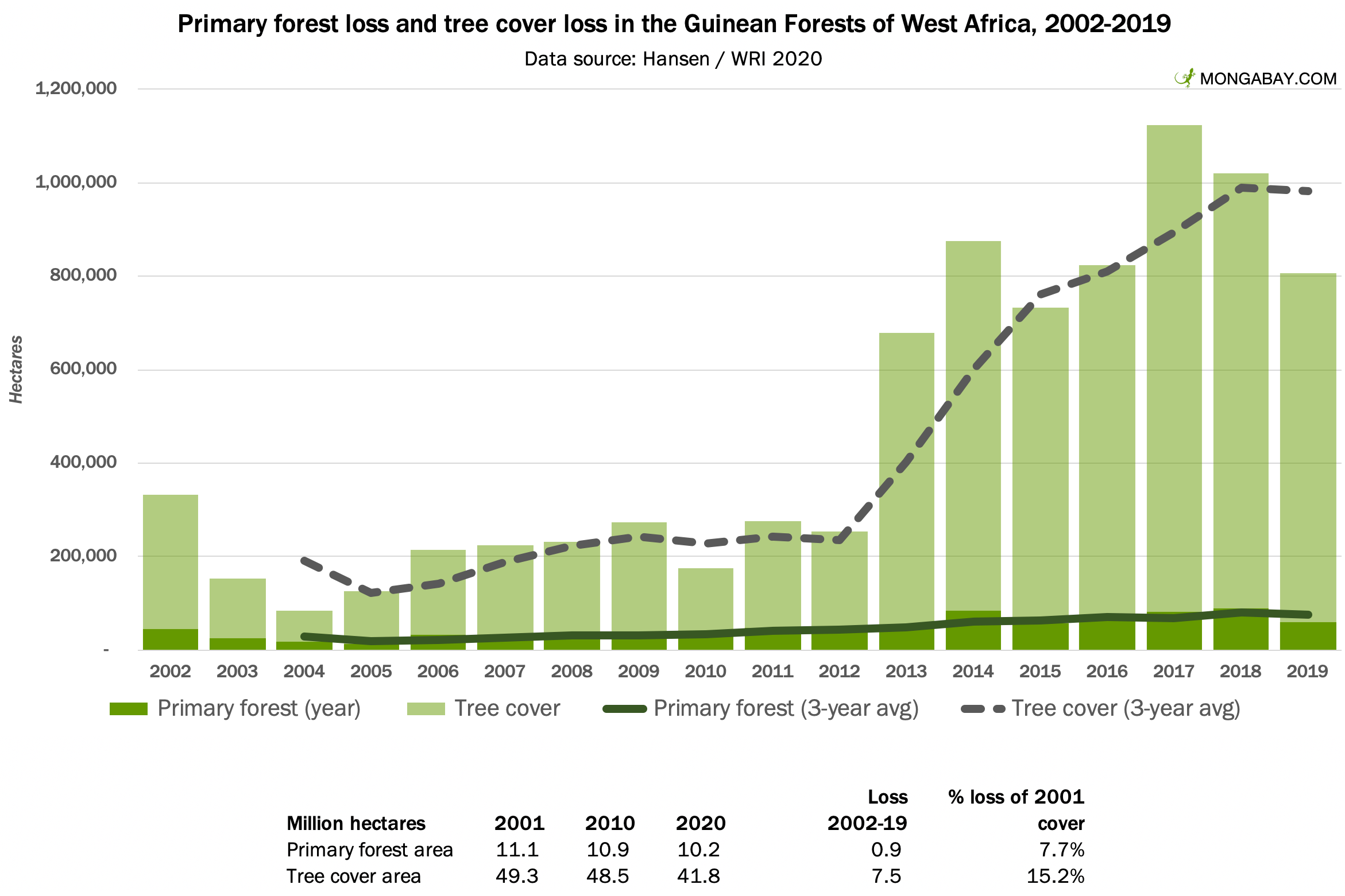
Extent: 42 million hectares of tree cover, including 10.2 million hectares of primary forest, in 2020.
Major countries: Liberia (41% of the region’s primary forest cover), Cameroon (17%), Nigeria (17%), Côte d’Ivoire (10%), and Ghana (10%).
Most famous species: Gorillas and chimps; pygmy hippo; various monkey species.
Deforestation trend: The rate of primary forest loss has been rising since the mid 2000s. Tree cover loss sharply accelerated in the 2010s. While Côte d’Ivoire accounted for only an eighth of the region’s primary forest cover in 2001, it had nearly 40% of total primary forest loss between 2002 and 2019. The country lost about a third of its total primary forests in less than 20 years.
8. Atlantic Forest
The Atlantic Forest once extended from northeastern Brazil into the hinterlands of Argentina and Paraguay. Today it has been greatly reduced by agriculture and urbanization. Most of the tree cover in this region is crops, plantations, or secondary forests.
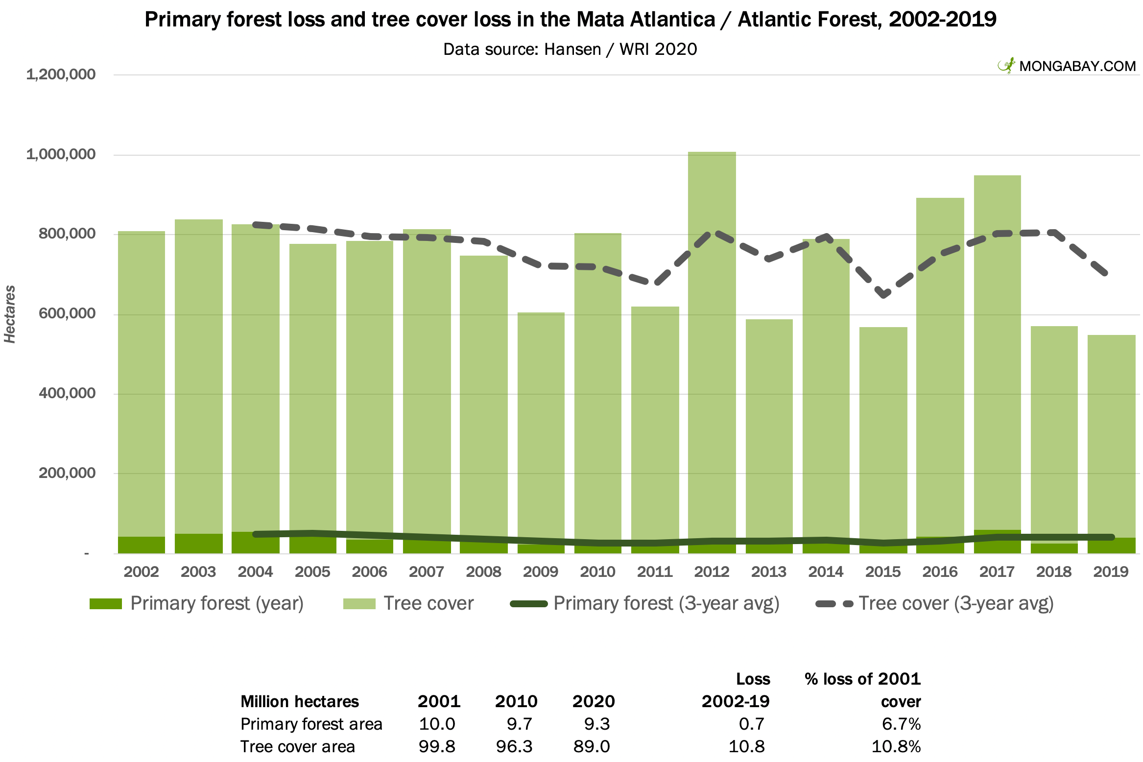
Extent: 89 million hectares of tree cover, including 9.3 million hectares of primary forest, in 2020.
Major countries: Brazil (86% of the region’s primary forest cover), Argentina (9.5%), and Paraguay (4%).
Most famous species: Jaguar; Puma; Golden Lion Tamarin; Howler monkeys.
Deforestation trend: The rate of primary forest loss in the Atlantic Forest—known as the Mata Atlântica in Brazil—has slowed since the 20th century, with annual deforestation remaining relatively flat.
9. Chocó-Darien
The Chocó rainforest extends from southern Panama and along the Pacific Coast of South America through Colombia and Ecuador. It is the world’s wettest rainforest and has the lowest deforestation rate of any of the regions covered in this post. The Chocó is home to both Amerindian tribes and Afroindigenous or “maroon” communities.

Extent: 15.6 million hectares of tree cover, including 8.4 million hectares of primary forest, in 2020.
Major countries: Colombia (79% of the region’s primary forest cover), Panama (13%), and Ecuador (8%).
Most famous species: Jaguar; Puma; various monkeys.
Deforestation trend: Primary forest loss in the Chocó amounted to 1.4% of its 2001 extent between 2002 and 2019. Ecuador and Panama accounted for a disproportionately large share of this loss.
10. Other Regions
This list is limited to the ten largest rainforests. Missing the cut are the forests of the Eastern Himalayas; East Melanesian Islands; the Philippines; Indian Ocean islands, including Madagascar; Eastern Afromontane; the Western Ghats and Sri Lanka; the Caribbean; and Polynesia-Micronesia.
This article was originally published on Mongabay, written by Rhett A. Butler, and is republished here as part of an editorial partnership with Earth.Org.