Recent images from NASA’s Earth Observatory show the Louisiana coastline fading into the sea as a consequence of decades of human development around the delta. The region’s story is one of great human adaptability, but also of its inevitable, at times even tragic limitations, in such a task as the control of nature.
—
Land loss in Louisiana
Land loss is one of the more visible manifestations of environmental change, requiring only a photograph taken from high enough up to prove its existence.
The two images below show one of Louisiana’s major bays, Barataria Bay, in 1985 (top image) and just last year, in 2020 (bottom image). 1 At first glance these seem similar, but zooming in one can see the brownish areas in the 2020 image are actually areas of water covering what were once green bits in the 1985 photo. Note for instance the area just south of the Mississippi River on the photographs’ top right.

Louisiana’s Barataria Bay region, imaged August 31, 1985 (top), and October 2, 2020 (bottom). Source: NASA Earth Observatory
The coast here loses a football field of land every 90 minutes. That was reported by the USGS in 2011 and the phrase spread like wildfire, evoking both fear and doubt, but it was a simple statement of the truth.
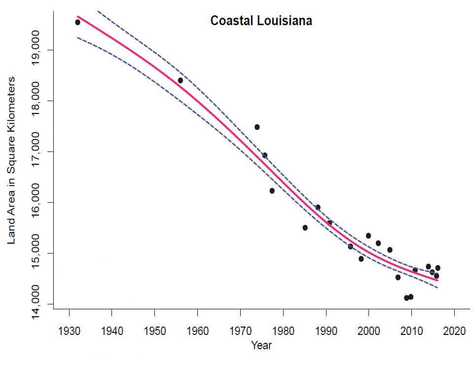
Records of land area change began in the 1930s and they show a consistent trend (graph below). The slight slowdown in recent years has made for a few optimistic headlines, but researchers attribute this to there not having been as many major hurricanes since 2008 (a trend not guaranteed to continue) and the fact that the most vulnerable areas have already disappeared (ref. 2).

Land area in Coastal Louisiana from 1932 to 2016. Black dots indicate observations; red line indicates the average trend and blue dotted lines its 95% confidence interval. Source: USGS (public domain)
Why the coast is shrinking
The Louisiana Gulf coast is the youngest land in North America, if not the world. Some of its southernmost areas formed only about 550 years ago, not too long before Columbus arrived on the continent – a mere moment in geological time scale (ref. 3).
The land is so new because it forms as the Mississippi River periodically swells and floods the region, leaving behind a fresh layer of sediment once the waters subside. This is natural and gradual, a process of slow build up that counteracts the also natural, steady erosion from winds, storms, and subsidence. New Orleans was actually originally called the ‘Island of New Orleans’ by the French, L’Isle de la Nouvelle Orléans, as these lands have always been wetlands, already underwater to some degree (ref. 4).
The familiar boot shape of Louisiana would look very different if maps depicted only its solid land, highlighting how much of the state is in a precarious position between watery ground and open ocean (below) (ref. 4).

How Louisiana is usually shown on maps (left) versus how it would look if maps depicted only solid land (right). Source: LaTigre, The New Yorker.
Eighteenth century settlers first tried bridling the Mississippi’s natural floods in order to set up forts and towns. They built levees to keep the river within its banks and drainage channels to guide whatever did flood straight out to sea. That continued in the 300 years since, with the region now crisscrossed throughout with artificial barriers and canals (ref. 3).
Constricting the river this way essentially prevents any new land from forming.
Even if the river were still free to ebb and flow, its new sediment layers would be anomalously vulnerable as nearby marshes and mangrove shrubs, the area’s protective buffers, i.e. what kept runoff from leaving too fast and seawater from surging too strong, have been increasingly cleared for development and/or deteriorated by climate change. Saltwater intrusion via oil and gas canals also kills off much of the vegetation, leaving the sediment easier to erode; some studies attribute up to 50 percent of Louisiana’s wetland loss to this (ref. 3).
Then there is sea level rise, perhaps the most overwhelming reason for further projected deltaic land loss, not to mention an ubiquitous consequence of anthropogenic global warming (ref. 3).
Adaptation – or its attempt
The Bayou State is thus in a race to keep from going under. Tens of millions of dollars have been set apart for enormous steel drills and bulldozers to artificially mimic what the river had already been doing for centuries. Marsh creation and restoration projects are proceeding alongside plans for increased flood protection infrastructure despite it being generally well known that the latter somewhat, and sometimes very much, defeats the former (ref. 4).
To just break even with the current rate of land loss, about twenty acres of new manmade land would have to be created every day. Additionally, some of the land ‘made’ in recent years has already itself begun to disappear, likely to be lost below the Gulf in a matter of decades (ref. 4).
The engineering and ingenuity behind these adaptation master plans are admirable in scope and tenacity, but the overall situation maintains an inevitable result. The story of Louisiana’s shrinking coastline is in some ways a harbinger for other low-lying regions, like New York, Miami and Shanghai, in regards to risk management and the challenges of resettlement and recovery. 3
It may also present an opportunity to step back and rethink the limitations of our ability to make nature fit with our conveniences. Yes the Louisiana coastline is being lost, but it was never really meant to be dry and permanently habitable in the first place. The same is true for other regions of the US seeing significant wetland loss, the primary drivers being development and agriculture. 5
“Give me Louisiana” is the Louisiana state song, a bluesy ode to its rivers and sun and sweet magnolias, but with an almost ironically fateful double meaning as the land, despite valiant, expansive efforts, increasingly fades away.
This article was written by Debbie Sanchez.
You might also like: Insect Decline: “Death By A Thousand Cuts”
References
- https://earthobservatory.nasa.gov/images/147739/reshaping-coastal-louisiana
- https://www.usgs.gov/news/usgs-louisiana-s-rate-coastal-wetland-loss-continues-slow
- https://link.springer.com/chapter/10.1007/978-3-030-27205-0_2
- https://www.newyorker.com/magazine/2019/04/01/louisianas-disappearing-coastline
- https://www.epa.gov/sites/production/files/2015-04/documents/cwr_highlights-updated.pdf


![The Statistics of Biodiversity Loss [2020 WWF Report]](https://u4d2z7k9.rocketcdn.me/wp-content/uploads/2020/12/lprwinkyTHB-544x306.jpg)


