

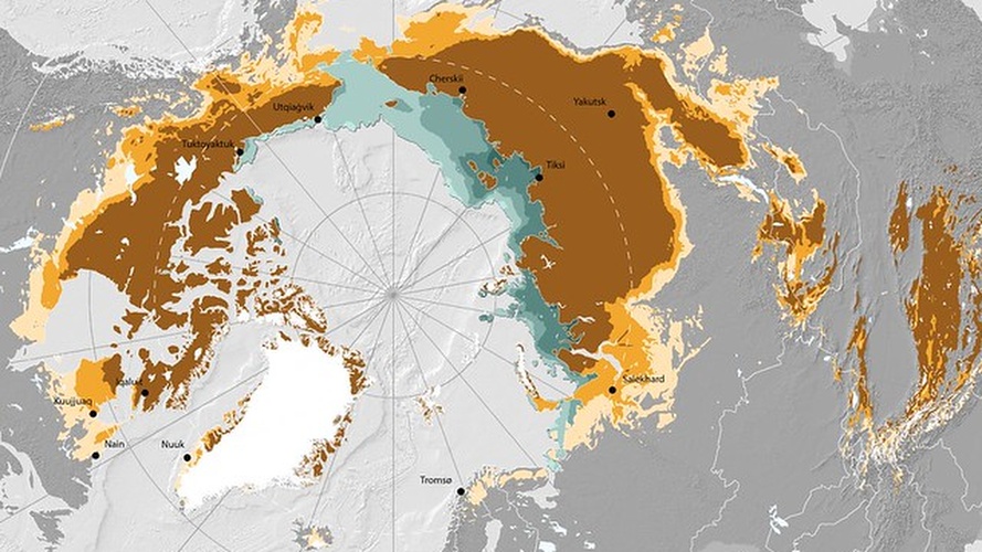
The Nunataryuk project aims to study permafrost distributions and trends, and how its melting could impact climate change and indigenous communities around the Arctic. This map used data obtained in 2019 to visualise terrestrial and submarine permafrost in the northern hemisphere (Source: GRID-Arendal/Nunataryuk).
—

This map shows terrestrial and submarine permafrost in the Northern Hemisphere. It was produced in 2020 as part of the Nunataryuk research project.
Over the summer of 2020, blazes, heat waves, and record high temperatures scarred the Arctic landscape. From temperatures reaching 37.8oC in June, to smouldering fires in the Arctic peatlands, disasters like these certainly had implications on what could eventually become of the Arctic permafrost. One project aims to study permafrost melt and its implications for climate change and human well-being, especially in indigenous communities. Studies like these could help set out climate adaptation and mitigation strategies.
The focus
Permafrost is technically ground that remains below freezing for a continuous period of at least two years. As it melts, it releases methane, a potent greenhouse gas, by microbial decomposition. This release of methane contributes to global warming, further exacerbating permafrost melt, forming a feedback cycle between permafrost melt and warming. Monitoring and quantifying these processes is challenging, and their potential impact make it paramount to do so.
Their activities
- Nunataryuk has contributed publications and data on various studies in Arctic sites, ranging from perception of permafrost thaw in impacted communities, to environmental sampling, monitoring and modelling to predict the future of Arctic permafrost.
- The generation of a new global permafrost map, displayed at the beginning of this article. It shows how ~10% of all northern permafrost is actually under the seabed, making it even more difficult to study than terrestrial permafrost.
Why projects like this matter
- The northern peatlands store an immense amount of carbon, which can be released upon thaw or combustion.
- Polar regions like the Arctic are warming three times faster than the global average, 3.29oC warmer than the 1981-2010 period as of today.
- These conditions could cause a snowball effect, melting the north polar ice caps, accelerating sea level rise, all while releasing the massive amounts of frozen carbon. We still have decades before such a scenario could really gain momentum, but it is important to keep an eye on all the same.
This article was written by Javier Chai Rui Cheng.
You might also like: Red Tides in the UAE
References
- A heat wave thawed Siberia’s tundra. Now, it’s on fire. (2020). Retrieved 13 December 2020, from https://www.nationalgeographic.co.uk/environment-and-conservation/2020/07/a-heat-wave-thawed-siberias-tundra-now-its-on-fire
- Foldable map shows permafrost around the world | GRID-Arendal. (2020). Retrieved 13 December 2020, from https://www.grida.no/news/13
- Permafrost in the Northern Hemisphere | GRID-Arendal. (2020). Retrieved 13 December 2020, from https://www.grida.no/resources/13519
- Sluggish Start for Arctic Sea Ice Freeze-Up. (2020). Retrieved 13 December 2020, from https://earthobservatory.nasa.gov/images/147633/sluggish-start-for-arctic-sea-ice-freeze-up
- Viitanen, L. (2020). New map shows extent of permafrost in Northern Hemisphere. Retrieved 13 December 2020, from https://nunataryuk.org/news/139-new-map-shows-extent-of-permafrost-in-northern-hemisphere


![The Statistics of Biodiversity Loss [2020 WWF Report]](https://earth.org/wp-content/uploads/2020/12/lprwinkyTHB-544x306.jpg)


