Rotterdam in the Netherlands is known to be at risk of being submerged due to sea level rise. Standing 20 feet below this threshold, the city has implemented innovative measures to live with Mother Nature instead of fighting it. Their best flood mitigation procedure is increasing the capacity of their whole city to capture water.
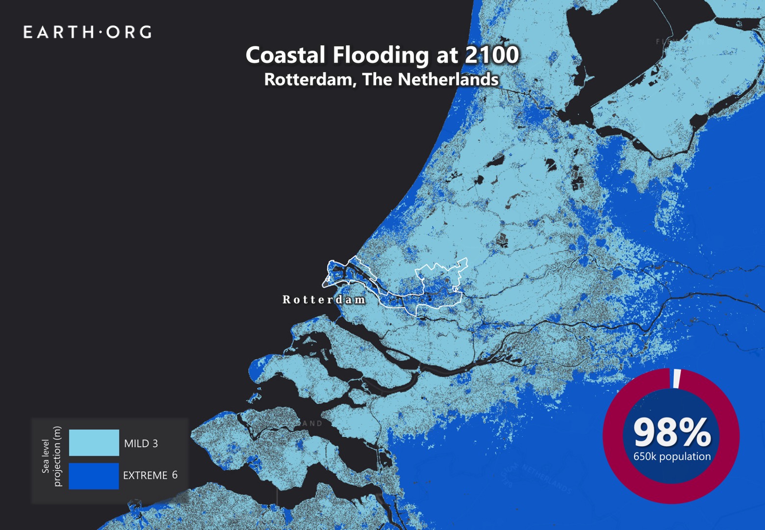
Earth.Org has mapped the high-level flood potential the low-lying city could suffer by 2100 with current sea level rise projections.
—
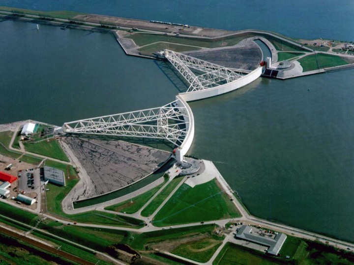
The Netherlands is well-known for being the leading country when it comes to battling floods. Danger is always lurking for provinces like Rotterdam that is located at the mouth of Nieuwe Maas channel leading towards the North Sea. Their biggest protection is The Maeslantkering, the Rotterdam dam that closes once storm surges exceed 3 meters height.

By John Englander February 11, 2019.
The Maeslantkering itself has only had to close twice in 22 years. Projected frequencies of storm surges might force it to close once annually in the near future. Despite that, Rotterdam refuses to “keep building higher levees, because we will end up living behind 10-meter walls,” said Harold van Waveren, a senior government adviser. Instead, the Dutch have opted to give Room for the River. Letting water in and live with it.
Infrastructures all across the province have the added function of water storage to help mitigate flooding. Parking garages are transformed into emergency reservoirs, and open plazas are designed to fill up, with drainage systems that redirect water back to the river. Concrete pavement in gardens around neighborhoods have been removed to increase water absorption capacity, and crops are also carefully selected and modified to adapt with saline water.
Besides storm surges, Rotterdam often gets an abundance of rain showers. Excess downpour is controlled by rooftop farms holding up to 60 liters of water per square meter. Built-in Smart Roofs monitor rain forecasts and adjust their flow.
Despite the cutting edge strategies employed in Rotterdam, these will not be enough to contain the projected 1 to 2 meter rise in sea levels by 2100. However, it may buy them enough time to come up with another solution, such as relocation. Earth.Org has modeled what extreme flooding could look like in Rotterdam by 2100 to help you visualize the impending threat.

Sea level rise projections by 2100 for two scenarios with the amount of rise in meters indicated (mild = 3m; extreme = 6m). Percentage and total population displacement indicated bottom right.
Methodology
Global mean sea level is projected to rise by 2m at the end of this century. However, in order to determine local sea level rise (SLR), one has to take into account local coastal flood levels which could be 2.8m above Mean Higher-High Water (MHHW) at extreme forecasts. These local levels bring variability to the projected SLR from 1m to 6.5m (eg. Rio vs Kolkata).
The SLR scenarios used in this study are based on the forecasts from Climate Central – Coastal Risk Screening Tool with the following parameters:
- Sea level Projection Source
- Coastal Flood Level
- Pollution Scenario
- Luck
Sea level Projection Source:
From two highly cited journals by Kopp et al., estimating SLR mainly due to ocean thermal expansion and ice melt. The mid-range scenario projected 0.5-1.2m of SLR based on different representative concentration pathways (RCP) defined by the IPCC. While the pessimistic scenario added more mechanisms of ice-sheet melting, estimating SLR at 1m-2.5m in 2100, with a projection of 10m SLR at 2300.
Coastal Flooding
More frequent coastal flooding is a direct impact of sea-level rise. Based on the Global tides and surge reanalysis by Muis et al., (2016), it is estimated that the extreme coastal water level could be from 0.2 – 2.8m over the mean level. While in extreme cases like China and the Netherlands it could experience 5-10m of extreme sea levels. Here, the coastal local flood level is added on top of the projected SLR.
Pollution Scenario:
Allows choosing the RCP, the greenhouse gas concentration trajectory defined by the IPCC. The mild level is based on RCP4.5, of 2°C temperature rise; while the Extreme level is based on RCP 8.5, of 4°C temperature rise.
Luck:
Applies to the baseline SLR, defined in the “Sea level projection” section, upon which we add flooding. “Mild” refers to the mid-range scenario of 0.5-1.2m, and “extreme” to the pessimistic scenario of 1-2.5m. We used the high-end value of each scenario (mild = 1m; extreme = 2.5m).
You might also like: Sea Level Rise by the End of the Century – New York City
This article was written by Eva Angela Seputra and Owen Mulhern.
References:
-
Kulp, Scott A., and Benjamin H. Strauss. “New elevation data triple estimates of global vulnerability to sea-level rise and coastal flooding.” Nature communications 10.1 (2019): 1-12.
-
Florczyk, A. J., Corbane, C., Ehrlich, D., Freire, S., Kemper, T., Maffenini, L., Melchiorri, M., Politis, P., Schiavina, M., Sabo, F. & Zanchetta, L. (2019). GHSL Data Package 2019 Public Release.
-
Kopp, R. E., DeConto, R. M., Bader, D. A., Hay, C. C., Horton, R. M., Kulp, S., Oppenheimer, M., Pollard, D. & Strauss, B. H. (2017). Evolving Understanding of Antarctic Ice-Sheet Physics and Ambiguity in Probabilistic Sea-Level Projections. Earth’s Future, 5(12), 1217–1233.
-
Kopp, R. E., Horton, R. M., Little, C. M., Mitrovica, J. X., Oppenheimer, M., Rasmussen, D. J., Strauss, B. H. & Tebaldi, C. (2014). Probabilistic 21st and 22nd Century Sea-Level Projections at a Global Network of Tide-Gauge Sites. Earth’s Future, 2(8), 383–406.
-
Kulp, S. A. & Strauss, B. H. (2019). New Elevation Data Triple Estimates of Global Vulnerability to Sea-Level Rise and Coastal Flooding. Nature Communications, 10(1), 4844. Retrieved June 21, 2020, from http://www.nature.com/articles/s41467-019-12808-z
-
Muis, S., Verlaan, M., Winsemius, H. C., Aerts, J. C. J. H. & Ward, P. J. (2016). A Global Reanalysis of Storm Surges and Extreme Sea Levels. Nature Communications, 7.


![The Statistics of Biodiversity Loss [2020 WWF Report]](https://u4d2z7k9.rocketcdn.me/wp-content/uploads/2020/12/lprwinkyTHB-544x306.jpg)


