On October 30th, 2012, New Yorkers woke up to a city devastated by Hurricane Sandy. Never before had New York City’s vulnerabilities to sea level rise and flood inundation been laid so bare. Hurricane Sandy produced a 2.7-metre storm surge, which coincided with a high tide. Water levels topped 3.9 metres at their highest, a metre higher than is required to flood the city’s extensive subway network. Hurricane Sandy was a devastating and unprecedented disaster. At the same time, it gave New Yorkers a terrifying glimpse into the future, as the sea level in NYC is projected to rise 40 centimetres by 2050 and between 2-5 metres by 2100.
—
New York City is uniquely vulnerable to sea level rise and flooding from weather events. The city was developed with two underlying principles, the first was the presumption of a stable shoreline that did not shift and change with tidal forces like other coastal cities in the US like New Orleans. The second was that colonial-era city planners assumed that the NYC region was not at risk from things like hurricanes, and tsunamis, and so placed most critical infrastructure in close proximity to its 2,400-kilometre-long waterfront. The city’s waterfront propelled it to its modern position as one of the most influential and wealthy urban centres in the world, yet is it this same waterfront that is the city’s most existential threat.
Sea Level Rise NYC
People generally don’t think of NYC as a place that is vulnerable to hurricanes, but hurricanes, post-tropical cyclones, and major coastal storms occur frequently around the region. Since 1970, 26 hurricanes have hit the New York region. Compounding the problem is the fact that the New York Harbor creates a funnel that encourages storm surge to build up around the city, which is populated across several islands and peninsulas. As sea levels rise, the base water level gets higher, so storms that previously wouldn’t have caused major problems in the city will start to cause major flooding. NYC is also the most densely-populated city in the USA, meaning that a storm that only floods a small area can still impact a lot of people.
At the same time, climate change is making storms stronger. The oceans have absorbed up to 90% of the excess heat generated by climate change and global heating; warm ocean waters are the ‘batteries’ that power storms like hurricanes. Warm air is also better at holding moisture, which can make storms produce more precipitation, and can cause surface flooding. In 2021, Hurricane Ida slammed into the Louisiana coastline, as the remnants of that hurricane moved across the United States, they combined with other storms and eventually made their way to New York City. Ida dropped between 22-30 centimetres across the region and caused 16 deaths in NYC as highways, subway tunnels, and basement apartments flooded.
You might also like: Air Pollution in NYC: Causes, Effects, and Solutions
Impacts on the New York Subway System and Commercial Transportation
The most critical piece of infrastructure in NYC is the subway, which has the highest ridership of any public transportation network in the western hemisphere. The subway system services 2.4 million daily riders, who use it to commute to work, and school, and depend on reliable, safe service no matter the weather. NYC’s subway system consists of 1,070 kilometres of track, of which 672 kilometres are underground. Many of the system’s stations are located at natural drainage points or are located on low-lying coastal land. Even on dry days with good weather, the Metropolitan Transportation Authority (MTA) pumps 53 million litres of water out of the subway system, but during inundation events, the pumping system can be quickly overwhelmed, especially because draining the subway system requires a fully functioning sewage treatment network.
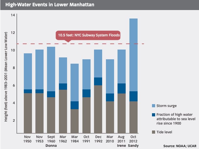
Chart displaying risk to subway system by high water events in Manhattan taken from NYC Report on Hurricane Sandy and its Impacts
New York’s sewage treatment system uses a combined sewer system. In combined systems, stormwater and floodwater enter the sewer system through storm drains, and join household and commercial sewage, which is treated, and then dumped into the New York harbour. In extreme rainfall events, the system is designed to discharge untreated sewage directly into the harbour in order to protect sewage treatment plants from being overwhelmed. Raw sewage is discharged into the New York Harbor, and sometimes individual outflows can discharge more than 70 times per year, an event known as combined sewer overflows (CSOs). However, if sewage treatment plant outflows are inundated with seawater, then seawater can flow backwards and discharge the combined sewage and stormwater out of toilets, sinks, storm drains, and into subway tunnels.
Floodwater can also enter the subway system through vents, and stairwells, which is what happened during Hurricane Sandy. Sandy caused the most damage to the subway system in its entire history, and subway service continues to be impacted by Sandy to this day, several subway tunnels took days or weeks to fully drain, and many of the electronic components along subway lines were damaged or destroyed.
Impacts to New York City’s Sewage Treatment Network and Electric Grid
Disruptions to sewer treatment plants would have ramifications beyond the subway.
According to an executive summary on climate resiliency done by the New York City Mayor’s office, “all [of the city’s] 14 wastewater treatment plants and 60% of pumping stations are at risk of flood damage.” The report also found that flooging risk is likely to increase over time, as climate change is expected to result in more extreme and frequent storm events and consequently sea level rise in the coming decades.
If the city’s network of sewage treatment plants – which process 5.3 billion litres of sewage on sunny days – failed, it would pose a huge risk to New Yorkers’ health and the city’s environment. While sewage treatment plants are not likely to fail during a single storm surge event, plants will face compounding damage from events over time, and if no measures are put in place to protect sewage treatment plants from sea level rise and storm surge, the city estimates that damages will cost more than $2 billion by 2050.

Map of sewage treatment plants at risk of storm surge inundation taken from NYC Climate Resiliency Executive Summary
Of course, the city couldn’t function at all without electricity from its grid. NYC makes a great deal of electricity within city limits. Most of the power plants in New York have been in continuous use for 150 years, having been retrofitted and converted to burn gas instead of coal. However, a lot of plants and transformers (which distribute power) are located along the shoreline both to intake water for cooling and also because in the past, being right on the shoreline made it easier for coal to be delivered directly to power plants from boats.
New York City also gets a lot of its energy from across New York State. However, the energy mix of New York State has recently undergone drastic changes. New York State operated three nuclear power plants which provided nearly a quarter of all the state’s electricity until 2021, when it shut down Indian Point Power Plant which is roughly 100 kilometres north of NYC, and distributors worry about supplementing that lost power without causing more emissions.
NYC consumes 60% of all electricity produced in New York State, but it only produces 40% of the total energy produced in New York State. It is incredibly hard to provide NYC with adequate power when the local power plants, or transformers,. 60% of the city’s power plants and grid infrastructure are at risk from flooding and sea level rise and need to be relocated, protected, or raised as soon as possible. Additionally, much of the city’s gas storage network is also vulnerable to sea level rise and flooding. Renewable usage is on the rise in NYC, which could present opportunities to add more energy sources that aren’t so vulnerable to sea level rise. New York State recently introduced a proposal to build the largest offshore wind farms in the USA, which will come online (at this year).
You might also like: EV Revolution: New York Becomes 2nd State to Ban Fossil Fuel Cars by 2035
Sea Level Rise and Environmental Justice
New Yorkers living in neighbourhoods most at risk of inundation are also the poorest. Even though shoreline real estate across the city is generally the most expensive, residents living along the Jamaica Bay saltwater estuary live in neighbourhoods close to the sea, on a very gradual slope. According to the visualisation above, Manhattan (the island at the centre of the image) is clearly naturally more protected than areas surrounding Jamaica Bay, which is closer to the bottom right of the visualisation below.
 LEFT: A projection of sea level rise by 2100 in NYC and the surrounding areas. Graph by Earth.Org. RIGHT: Map of income distribution in NYC taken from Vivid Maps
Protecting NYC from sea level rise and storm surge is clearly an important task. NYC is the financial centre of the eastern United States and in 2021 had a GDP of %1.7 trillion. New York City is one of the largest economies in the world, and any significant damage to the city would have rippling effects across the global economy. However, any plan to solve the problem of sea level rise needs to protect all New Yorkers first.
What Is NYC Doing to Prepare for Sea Level Rise?
Protecting NYC from sea level rise is a monumental challenge, and one intervention won’t work for everyone. In some cases, sea walls and levees are the answer, but other strategies like managed retreat, and using protective ecosystems are just as important.
After Hurricane Sandy resulted in $19 billion in damage to NYC, former US President Barack Obama, in cooperation with Governors from six states, announced a federal plan to combat future storm surges and sea level rise called Rebuild by Design. The winning design, dubbed ’The Big U’, won a $2.5 billion contract. Proposed by Dutch architectural firm BIG (Bjarke Ingles Group), the project would protect lower Manhattan – home to 220,000 people and the $500 billion business sector that influences the world’s economy.

Rendering of ‘the Big U’ done by Dutch architecture firm BIG, taken from Architecture Daily
The Big U was initially praised for including residents of the Lower East Side living in one of the largest public housing projects in the US. The project initially aimed to extend the East River Park, which has been an icon of New York City green space for more than 80 years, to establish a raised berm, and then saltwater marshlands designed to flood in storm surge events. The original plan wouldn’t have disrupted existing park space, but in 2018, the DeBlasio administration did a ‘feasibility study’ and found that the plan would be too disruptive to traffic, power lines, and gas infrastructure. The plan was scrapped and instead, the East River Park would be destroyed and then raised 2 metres higher, to act as a storm surge barrier. It was a politically motivated plan to satisfy private interests surrounding the park and it worked. Lower-income residents in the East Village were unhappy with the revised plan, but they felt that if they rejected it, the city wouldn’t propose alternatives and would instead leave them to face sea level rise and storm surge alone.
In Staten Island, where Hurricane Sandy ravaged low-lying neighbourhoods, a different strategy was pursued. The Build it Back program was launched by the New York City Mayor’s Office of Housing Recovery Operations to help residents impacted by Sandy to repair and rebuild their homes, or relocate entirely. Some residents have been paid to move further inland, which some say can be used as a model for people living in at-risk areas worldwide.
Other groups want to recognise New York City’s past as a naturally resilient and diverse landscape. The land where New York City is located was once called ‘Lenapehoking’ which means ‘the home of the Lenape’. Before colonisation, indigenous Lenape people lived among the forests, meadows, and marshlands of Manahatta (now Manhattan), Long Island, New Jersey, and Delaware. Dutch (and then later English) settlers removed Lenape people from their land to create New York as it is known today.
New York City’s existence is intrinsically tied to genocide, colonisation, and the violent removal of indigenous people from their ancestral lands. Restoring ecosystems that protect inland areas from storm surge and sea level rise is one way for the city to reconcile with its violent past. Before colonisation, the land where NYC now sits was incredibly biodiverse and home to more than 50 distinct ecosystems, including oyster reefs, saltwater marshes, sand dunes, coastal forests, wildflower meadows, and woodlands.
Non-profit organisations like the Billion Oyster Project work to restore oyster reefs to the New York harbour. Oysters are incredible at filtering pollutants out of the water. They are also amazing at protecting coastlines from violent wave action and storm surge. Oyster reefs grow vertically as sea levels rise, and so these ‘living breakwaters’ could play an important role in protecting people from the ramifications of the climate crisis. Other groups, like the Newtown Creek Alliance, advocate for saltwater marsh restoration, as saltwater marshes also pad coastlines from storm surge and inundation. The Rockaway peninsula, which was devastated by Sandy, has rebuilt its iconic pier using ‘living’ sand dunes, and the city is reintroducing sand dune plants to make them less susceptible to erosion.
You might also like: Using Oysters as a Flood Defence Strategy
Conclusion
New York City is faced with a huge problem when it comes to sea level rise, and storm surge worsened by climate change. The city needs to rethink its relationship to the ocean that surrounds it while maintaining a high quality of life for its residents. Clearly, a diverse array of solutions are needed, projects like The Big U are important for protecting large swaths of vulnerable coastline, but other solutions can offer just as much help, like ecosystem restoration and reintroducing coastal habitats. NYC has an incredible opportunity to make itself more resilient in the face of climate change, but current proposals fall short when it comes to protecting everyone.
You might also like: Sea Level Rise Projections: Top 10 Cities at Risk of Flooding